On the 6th July 2011 UK Discovery and DevCSI started running a competition to encourage the creation of tools/applications that make use of one or more of their open data sources.
Did it work? Well having looked at their open data sources I decided to create an application that would help visualise the English Heritage Places dataset and link it with the British National Bibliography dataset. What’s About is the resulting webapp.
You can have a play with What’s About by pointing your browser at http://whatsabout.lboro.ac.uk/whatsAbout/
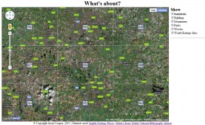
If your browser supports the W3C Geolocation API then you will initially be prompted asking if you want What’s About to know your location. If you say yes it will use your location as the basis of the map, if you say no or your browser doesn’t support the W3C Geolocation API then the map will display around the Loughborough, Leicestershire, Nottinghamshire area, though you can move around the map and zoom in and out to look at areas that you are interested in.
The core of What’s About is the map, which takes up most of the window and the options column on the right hand side. The options column contains a list of place types which can be used to limit down the places shown to specific types. If there are over 100 places within the current map view then a grid is shown on the map. A count of the number of places located within each cell of the grid is shown in the center of each cell
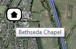
If there are less than 100 places located within the current map view then each location will be shown on the map with an icon. The icon shows the type of place and if you hover over an icon the name of the place will appear.
The names of the places shown on the map will also appear in the options tab on the right. If you wish to locate a specific entry from the list clicking on its name will cause its icon to bounce up and down on the map for a few seconds.
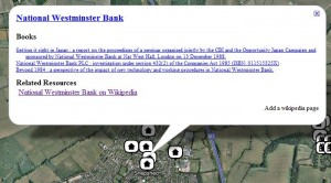
Clicking on an icon will bring up a window with some resources for that place, including a link to the original record in the English Heritage Places dataset, a list of books with the place name contained in the title and a list of links to relevant online resources.
The books are taken from the British National Bibliography dataset and Related Resources links can be added by anyone using the “Add a wikipedia page” option at the bottom left of the window. Currently only a Wikipedia URL can be entered for a Related Resource to reduce the risk of it being used to add spam, though in the long term this could be opened out to any URL provided that there were enough moderators available to remove any spam links.
There is also an extractLinks API that will return a JSON object containing the English Heritage URIs for places with attached online resources, along with the URLs and Titles for the links.
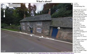
Because it is built on Google Maps technology you can also use the street view (provided there is a street view available for the area) and the icons currently shown on the map will appear in the street view helping you identify the actual places you are looking for.
The code behind What’s About is available as open source via a GPL licence. The current version of the code can be downloaded from http://whatsabout.lboro.ac.uk/whatsAbout/WhatsAbout-1.tar.gz
Update: Well I have just found a few more bugs and also improved the street view functionality so that it now updates the places on the map as you move about. The new version of the code is available from http://lb-public.lboro.ac.uk/whatsAbout/WhatsAbout-1.1.tar.gz


