The Sandbox Project: Using Augmented Reality to Improve Geomorphological Understanding
Continuing our series of updates on the 2016 Teaching Innovation Awards, Prof. Jo Bullard explains how a regular sandbox can be transformed into a unique teaching and learning experience.
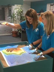
Many students and visitors to the Geography  Social learning Space over the past few weeks have stopped for a few minutes (or longer!) to interact with the Sandbox that is currently under development. What is so special about a box of sand? Well this one has been built using a 2016 Teaching Innovation Award aimed at using augmented reality to improve geomorphological understanding. When the box of sand is connected to a camera and projector it becomes possible for users to create and visualize landscapes. As the sand is sculpted, contours are projected on to the miniature landscape. By hovering a hand over the box, users can make it ‘rain’ over the landscape and the water flow down in to rivers and valleys.
How was it developed?
The basic programming for the Sandbox is open source software developed at UCDavis and Computer Science student Yuan Tian and technician Kip Sahnsi worked last summer to get the computer code running on a special computer. In the meantime Joanna Bullard and Richard Harland in Geography built the box which is on wheels so that it can be transferred between Geography and Computer Science and also to other events on campus.
What’s next?
There are a few sandboxes now up and running in the UK. In December 2016 Prof. Jo Bullard from Loughborough University, Dr. Annie Ockelford (University of Brighton), Dr. Lynda Yorke (Bangor University) and Dr. Chris Skinner (University of Hull) jointly convened a session at the American Geophysical Union Fall meeting on Technology-Enhanced Teaching in Geosciences which featured a number of papers exploring how to support undergraduate student learning using augmented reality and we are hoping to include some of these ideas in our teaching in the future.
The Loughborough Sandbox is currently being ‘tweaked’ to improve the visualization and accuracy of the projection data but will be back up and running soon.